- NV Science Team
- Professional Learning
- HS Biology
- HS Earth & Space
- Earth Science SY 23-24
- Chemistry
- Physics
- Living Environment and Earth Science Archive
- LE Resources: LE Getting Started
- LE Unit 1: LE: Characteristics of Living Things
- LE Unit 2: LE: Nutrients, Energy, and Biochemical Processes
- LE Unit 3: LE: Homeostasis in Human Body Systems
- LE Unit 4: LE: Disease and Disruption of Homeostasis
- LE Unit 5: LE: Comparative Reproduction
- LE Unit 6: LE: Genetics, Biotech, and Decision-Making
- LE Unit 7: LE: Ecosystems and Invasive Species
- LE Unit 8: LE: Climate Change and Human Impact: Extinction vs. Evolution
- LE Regents Prep Resources: Living Environment Regents Prep Resources
- LE Data Tools: Living Environment Historical Regents Data
- ES Resources: ES: Getting Started
- ES Unit 1: ES: Origin of the Universe and Our Solar System
- ES Unit 2: ES: Earth's Interior and Plate Tectonics
- ES Unit 3: ES: Landscapes and Surface Processes
- ES Unit 4: ES: Geologic History and Evolution of Life
- ES Unit 5: ES: The Earth-Sun-Moon System
- ES Unit 6: ES: Weather
- ES Unit 7: ES: Geography, Climate, and Human Cities
- ES Unit 8: ES: Review of Major Topics
- ES Regents Prep Resources: Earth Science Review Modules
- ES Data Tools: Earth Science Historical Regents Data Tools
- Bulk Downloader Demo Video
Find Resources
Search and browse resources for your classroom.
Use the filters below to see resources for a specific course, unit, and more.
Curriculum:
Filter By:
Type
Standards
- Earth Science (NY State Core Curriculum, 2005) - Standard 4
Showing 12 Resources:
Clear Filters
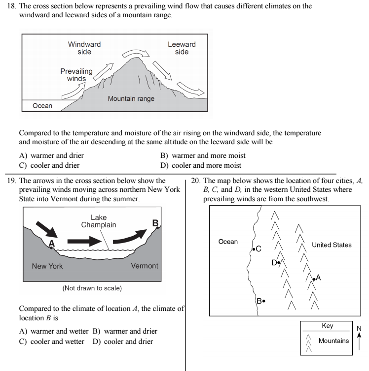
Altitude, Mountain Ranges, and Bodies of Water 5E Instructional Model Plan

Resource:
Altitude, Mountain Ranges, and Bodies of Water 5E Instructional Model Plan
Students learn about rainshadow/orographic effect by making observations of mountain range and ocean location, direction of prevailing winds, and vegetation on each side of the mountain range in a region that exhibits rainshadow effect. Students then collect temperature and rainfall data from the same region and write an explanation for the climate categories found in the region investigated during the explore phase. Students apply their understanding of the processes that drive by rainshadow effect by explaining why large lakes located in cold climate regions can cause lake snow effect.

Discuss this resource
Please join the Disqus forum below to share questions, feedback, suggestions, or descriptions of your experience using this resource.
If you have found an error in this resource, let us know by submitting this form.
All Resources From:
Climate Change 5E Instructional Model Plan

Resource:
Climate Change 5E Instructional Model Plan
Students learn about the greenhouse effect and how an increasing concentration of greenhouse gases are contributing to a rise in average global temperature. Students further their understanding of how humans are contributing to current climate change by reading an interactive text and watching a video. Students extend their thinking by exploring the implications of climate change in the regions be analyzed for the performance task.

Discuss this resource
Please join the Disqus forum below to share questions, feedback, suggestions, or descriptions of your experience using this resource.
If you have found an error in this resource, let us know by submitting this form.
All Resources From:
Coastal vs. Inland Climate 5E Instructional Model Plan

Resource:
Coastal vs. Inland Climate 5E Instructional Model Plan
In this 5E lesson sequence students learn about how proximity to oceans impacts climate by collecting and graphing cooling/heating data for sand and water. Then students apply their learning to a climate through an analysis of two cities at similar altitude and latitude, one of which is coastal and one of which is inland. Students further their understanding of how oceans affect climate by exploring the climate implications of ocean surface current origin and temperature. Finally, students extend their thinking by learning how an El Nino event can affect the climate of western United States.

Discuss this resource
Please join the Disqus forum below to share questions, feedback, suggestions, or descriptions of your experience using this resource.
If you have found an error in this resource, let us know by submitting this form.
All Resources From:
Geographical Representations (Topographic/Contour Maps) 5E Instructional Model Plan

Resource:
Geographical Representations (Topographic/Contour Maps) 5E Instructional Model Plan
Students learn about topographic maps, including contour maps, by collecting data from a 3D model of a landform to create a contour map. Then the teacher provides direct instruction on contour map features, creating profiles, and calculating gradient, and students create profiles and calculate gradients for the contour map they created during the explore phase. Finally, students match typical geographical features to representations on a contour map and extend their thinking by identifying erosional processes on a contour map.

Discuss this resource
Please join the Disqus forum below to share questions, feedback, suggestions, or descriptions of your experience using this resource.
If you have found an error in this resource, let us know by submitting this form.
All Resources From:
Geography, Human Cities, and Climate Change Unit Plan

Resource:
Geography, Human Cities, and Climate Change Unit Plan
In this unit students will analyze and create topographic maps of human cities as they consider how geographical features such as oceans, lakes, and mountains have influenced where humans have chosen to live. Students will also make predictions about how changes in the Earth's surface features that may take place?whether due to climate change or other factors?can influence the migration of human populations in the future.

Discuss this resource
Please join the Disqus forum below to share questions, feedback, suggestions, or descriptions of your experience using this resource.
If you have found an error in this resource, let us know by submitting this form.
All Resources From:
How Does El Nino Affect Climate?

Resource:
How Does El Nino Affect Climate?
In this task, students explore the causes and effects of El Nino.

Discuss this resource
Please join the Disqus forum below to share questions, feedback, suggestions, or descriptions of your experience using this resource.
If you have found an error in this resource, let us know by submitting this form.
All Resources From:
Lake-effect Snow

Resource:
Lake-effect Snow
Students work in groups to learn about the causes of lake-effect snow.

Discuss this resource
Please join the Disqus forum below to share questions, feedback, suggestions, or descriptions of your experience using this resource.
If you have found an error in this resource, let us know by submitting this form.
All Resources From:
Make a Contour Map Lab

Resource:
Make a Contour Map Lab
Students learn about topographic/contour maps by collecting data from a 3D model of a landform to create a contour map. Students use this data to draw a topographic map.

Discuss this resource
Please join the Disqus forum below to share questions, feedback, suggestions, or descriptions of your experience using this resource.
If you have found an error in this resource, let us know by submitting this form.
All Resources From:
Regents-Based Item Bank - Geography, Climate, and Maps

Resource:
Regents-Based Item Bank - Geography, Climate, and Maps
The Regents Item Bank provides questions from past Regents exams aligned with the content of this unit.
Discuss this resource
Please join the Disqus forum below to share questions, feedback, suggestions, or descriptions of your experience using this resource.
If you have found an error in this resource, let us know by submitting this form.
All Resources From:
What Do the Contour Lines Tell Us?

Resource:
What Do the Contour Lines Tell Us?
Students test out their ideas and misconceptions about topographic by applying their thinking to a new problem: Contour Map/Geographical Feature Card Sort.

Discuss this resource
Please join the Disqus forum below to share questions, feedback, suggestions, or descriptions of your experience using this resource.
If you have found an error in this resource, let us know by submitting this form.
All Resources From:
What is Climate? 5E Instructional Model Plan

Resource:
What is Climate? 5E Instructional Model Plan
Students learn about climate zones by collecting precipitation and temperature data from various climate zones around the world. After reading a text about climate and climate categories, students attempt to identify the climate category to which each location they explored belongs. Students then test out their ideas and misconceptions about climate and weather by reading a series of statements and classifying them as statements about either climate or weather.

Discuss this resource
Please join the Disqus forum below to share questions, feedback, suggestions, or descriptions of your experience using this resource.
If you have found an error in this resource, let us know by submitting this form.
All Resources From:
Where Would You Live? Performance Task

Resource:
Where Would You Live? Performance Task
The distribution of human populations over time has been largely influenced by the Earth's geography and climate. As global climate changes, the impact on geography and climate will be profound, inevitably causing challenges to the quality of life and survival of human and animal populations, forcing migration. Where would you want to live in the future in order to ensure that you're comfortable and safe? Consider current geography and climate and how these might be impacted by climate change in the year 2100.

Discuss this resource
Please join the Disqus forum below to share questions, feedback, suggestions, or descriptions of your experience using this resource.
If you have found an error in this resource, let us know by submitting this form.
All Resources From: